


.jpg)


.png)

.png)
.png)
.png)
.png)


✔ Sveriges snabbaste och bästa support på drönare.
✔ Officiell DJI butik.
✔ Lagar om olyckan är framme.
✔ Alltid först i Sverige med nya modeller.
✔ Snabb leverans.
DJI GS PRO Enterprise V2
 Delbetalning från 1072 sek/månad
- Stockholm (butik & online order): Utgått ur sortiment
- Webblager (endast online order): 0

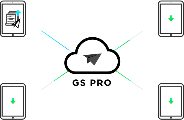
Förbättra dina drönar-operationer med DJI Ground Station Pro (DJI GS Pro), en iPad-app. Genomföra automatiska flyguppdrag, hantera flygdata på molnet och samarbeta över projekt för att effektivt köra ditt dröneprogram.
Dela produkten
- Produktinformation
- Material
- VANLIGA FRÅGOR OCH SVAR
Produktinformation
FLIGHT DATA MANAGEMENT
Back up flight data securely on the cloud, giving missions higher reliability and accuracy.
Reference historical information on flight missions, aircrafts, members, and flight logs so that workflows can be optimized.
Flight mission data is visible to all members of a project team, making data sharing easier.
Members can view edits made by other team members, or duplicate flight parameter settings for new missions.
FLEET AND PILOT MANAGEMENT
Manage pilots and drones through the creation of teams, making missions more coordinated.
Designate roles with different permissions to improve communication.
Track the status of aircrafts to make proactive purchasing and maintenance decisions.

PROJECT MANAGEMENT
Improve the efficiency of your drone operations by tracking individual projects and streamlining the project management process. Access to project status can be granted on a per project basis so that critical data is only available to the relevant members.

3D area map
Customized flight zone

Draw a custom polygonal flight zone on the screen or fly around the zone to mark its boundaries.
GS Pro automatically generates efficient flight paths after the user has set the required flight zone and camera parameters.
The drone will then follow this course throughout its mission. The image data acquired during these flights can be inserted into the 3D reconstruction software to generate 3D maps, while the mission itself can be saved for reuse.
Adjusting parameters

Adjusts parameters including photo overlap ratio, altitude, angle of view, parallel or vertical to the main flight path, course angle, and margin.
Capture images at equal time intervals, equal distance intervals or fly into place on a waypoint during capture.
Inside Mode and Scan Mode

Two flight modes are available: Inside Mode, where the drone follows an automatically generated route within the selected area, and Scan Mode, which provides the fastest route to cover a designated area.
Flight Plan Overlay Ratio

For better 3D reconstruction, the default photo overlay is optimized for a range of supported cameras.
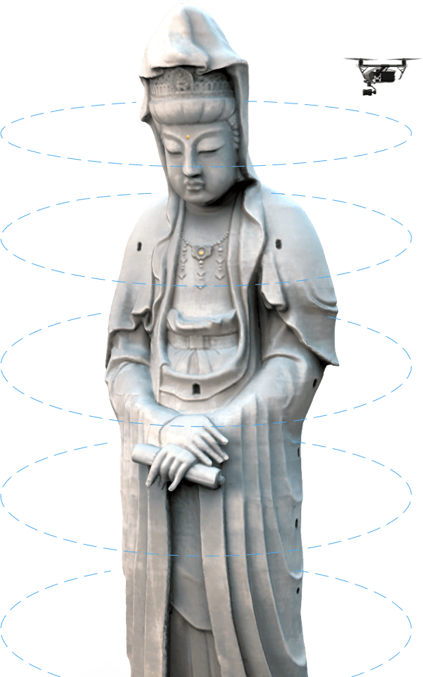
3D MAP POI IN-APP PURCHASE
Generate detailed maps of tall structures using 3D Map POI. Simply choose the subject and set a distance between it and the aircraft. DJI GS Pro will then provide relevant parameters including speed and time required to circuit the structure. Images captured can be exported into 3D reconstruction software to create accurate 3D models of the entire building.
Importing KML/SHP files

Increases construction mapping efficiency by importing KML/SHP files into GS Pro. KML/SHP files, which contain important geographic information, can be imported into GS Pro via PC or Mac wirelessly or directly from an iPad.
Once the geometries have been imported correctly, users can scroll left in the list of geometries in the Map panel and GS Pro will automatically generate a flight mission based on the geometry field, helping users to conduct the mapping with precision and ease.
Mapping with GS Pro becomes even more flexible by adjusting waypoints. If GS Pro fails to generate a geometry similar to the target building or sets a route of flight that is not able to provide a good result, users can still manually adjust waypoints by dragging or adding new ones to meet their needs.
Photomap

The new Photomap feature helps users efficiently create photo-based aerial maps. After users have completed an aerial photography mission in the desired area and imported the photos into GS Pro, the software will automatically create a composite photo of the area that users can adjust as needed.
Tap and Go Waypoint Flight
Multiple Waypoints
Set a route of flight with waypoints, define the actions of the waypoint, and then start flying with a tap.

Up to 99 waypoints are available, depending on the needs of each flight.
Adjustable parameters

Altitude, speed, gimbal pitch and drone rotation (clockwise or counterclockwise) at each waypoint can be predefined.
Different waypoint actions

Each waypoint can have up to 15 consecutive actions, including rotating the drone, pitching the gimbal, start/stop recording, capturing photos and flying into position.
Setting of end-of-mission actions

After the drone has completed its flight mission, it can be set to Return to Home, Hover or Land.
Virtual fence
The virtual fence defines a specific flight area and is useful in scenarios where some areas of the site are no-fly zones or if the flight should only take place within an area, for example during manual spraying of pesticides or flight. It is also useful in pilot training situations. As the drone approaches the virtual fence, it will stop and fly into place to make sure it stays within the flight area.
Setting the size of the fence

The size and shape of the virtual fence are fully customizable.
It can be created before the flight or fly around the area to mark the boundaries using the drone's GPS coordinates.
Speed and altitude

Sets the maximum speed and altitude for the drone when flying within Virtual Fences.
Industrial applications

DJI GS Pro is a powerful, convenient and easy to use tool. With just a few touches on an iPad, you can create complex flight paths, give critical missions more precision and reliability. DJI GS Pro is an indispensable tool that can dramatically increase efficiency in a wide range of industries.
Compatible products

DJI GS Pro is compatible with the following DJI aerial platforms and flight controllers:
Mavic 2 Enterprise, Mavic 2 Pro, Mavic 2Zoom, Mavic Pro, Phantom 3 Standard/Advanced/Professional/4K, Phantom4, Phantom4 Pro, Phantom 4 Pro V2/Advanced, Phantom 4 RTK, Matrice 200 V2, Matrice 210 V2, Matrice 210 RTK V2, Matrice 210, Matrice 210 RTK, Matrice 100,Matrice 600/Pro, Matrice 200, Inspire 1/Inspire 2, A3, N3
Compatible cameras:
Mavic 2 Enterprise, Mavic 2 Pro, Mavic 2 Zoom, Mavic Pro, Phantom 3 Standard/4K/Advanced/Professional,
Phantom 4/Pro, and Zenmuse X3, X5, X5R, X4S,X5S, Z3, Z30, XT, XT2 and Mavic 2 Enterprise Dual.
Material
The new version DJI GS Pro V 2.0.5 has released
Date:2019.06.12
DJI GS Pro V 2.0.5
What’s New?
1. [New] Add support for Matrice 200/210/210 RTK V2
2. [New] Display DJI Account Name in User Panel
3. [New] Remote Controller Calibration added
4. [Fix] Fixed the issue that 4K Video setting not could take effect in Mavic 2 Pro
VANLIGA FRÅGOR OCH SVAR
- 1.Does DJI GS Pro support Waypoint missions with more than 99 points?
Yes. However, when a flight mission has more than 99 waypoints, DJI GS Pro will automatically section the waypoints into groups, each containing a maximum of 99 waypoints. When each group of waypoint actions are completed, the mission will pause by default. You can continue the mission by using the “Resume from Last Stopped Point” function.
- 2.What devices support GS Pro?
GS Pro is supported on all iPad Air, Air 2, Mini 2, Mini 3, Mini 4, and Pro tablets (Android is currently not supported).
- 3.What mode should I switch my aircraft to for Ground Station Mode?
P Mode for the Phantom 4 and any aircraft released after the Phantom 4. F Mode for aircraft released prior to the Phantom 4, including the Phantom 3, Inspire 1, M100, M600 etc. Essentially, if the controller has an F Mode use F Mode, otherwise use P Mode.
- 4.What cameras does GS Pro support?
Mavic 2 Enterprise , Mavic 2 Enterprise Dual , Mavic 2 Pro, Mavic 2 Zoom, Mavic Pro, Phantom 3 Standard/4K/Advanced/Professional, Phantom4, Phantom4 Pro, Phantom 4 Pro V2/Advanced, Phantom 4 RTK(SDK Remote Controller), and Zenmuse X3, X5, X5R, X4S,X5S, Z3, Z30, XT2, and XT.
- 5.What DJI aircraft does GS Pro support?
DJI GS Pro is compatible with the following DJI aerial platforms and flight controllers: Mavic 2 Enterprise, Mavic 2 Enterprise Dual, Mavic 2 Pro, Mavic 2 Zoom, Mavic Pro, Phantom 3 Standard/4K/Advanced/Professional, Phantom 4/RTK/Pro/Advanced/V2, P4 Multispectral, Inspire 1/Inspire 2, Matrice 100, Matrice 200 V2, Matrice 210 V2, Matrice 210 RTK V2, Matrice 200/210/210 RTK, Matrice 600/600 Pro, A3, N3
- 6.What industries can use GS Pro?
GS Pro can be utilized in many industries including architecture, precision agriculture, aerial mapping, electrical inspection, security control, disaster monitoring, and more.
- 7.Does GS Pro support offline maps?
No. To use GS Pro without internet access, cache the map data first. Do not close or refresh the GS Pro page during use. When no internet is available, use the aircraft to create waypoints or define a flight area.
- 8.Is GS Pro able to calculate whether the battery can cover the entire mission?
No, but the current battery percentage is visible onscreen. GS Pro is able to continue a mission from a breakpoint, so when the battery is low, pause the mission, swap the battery and continue.
- 9.Is there a maximum distance limit?
If the farthest distance planned exceeds 2km, a warning will appear but the mission can begin.
- 10.What are Inside Mode and Scan Mode?
In Inside Mode, the aircraft follows an automatically generated route within a chosen area. In Scan Mode, the aircraft follows the fastest route to cover a designated area, which may result in flying out of the defined area.
- 11.Where does GS Pro map data come from?
From Apple Maps.
- 12.In a multi-aircraft mission, how many aircraft does GS Pro support? Do they have to be of same type?
Multi-aircraft missions are not currently supported.
- 13.What is the distance range between waypoints?
The distance between two adjacent waypoints can be from 1m to 2000m.
- 14.What happens if GS Pro loses control over the aircraft during a mission?
The aircraft will continue its mission and finish all planned actions.
- 15.What happens if I move a joystick during a mission?
Moving a joystick during a Waypoint Route mission will manually control the aircraft flight speed and heading. After releasing the joystick, the aircraft will resume its preset flight speed and heading.Moving a joystick during a 3D Map Area or 3D Map POI mission will manually control only the flight speed. After releasing the joystick, the aircraft will resume its preset flight speed.
- 16.Can I use the remote controller to record video or take a photo during a mission?
Yes, but this is not recommended as it may affect the mission.
- 17.If I activate Return to Home during a mission, will the aircraft return?
Yes.
- 18.Can I stop the motors during mid-flight?
Yes, if the stop-motor operation in DJI GO or DJI GO 4 has been enabled. This should only be used in an emergency.
- 19.Can I interrupt a mission at any time?
Yes.
- 20.What is the difference between Virtual Fence, GEO Fence and No-fly Zone?
A Virtual Fence is a user defined area in the GS Pro app. GEO Fence and No-fly Zone are pre-loaded by default in DJI aircraft and have a higher priority, thus user cannot edit GEO Fence or No-fly Zones.
- 21.Can I use in-app purchases on other DJI drones?
Yes, but the DJI drones you use must be compatible with GS Pro.
- 22.Can I edit flight missions before purchasing 3D Map POI?
Yes, you can create new flight missions and edit them before purchasing 3D Map POI. However, in order to upload missions to your aircraft and initiate them, you must first purchase 3D Map POI.
- 23.Does GS Pro have a flight simulation function?
No, but GS Pro is compatible with flight simulation. To do so, use the flight simulation function on DJI Assistant 2. Please note that the Phantom 3 series and Inspire 1 do not support DJI Assistant 2, and therefore do not feature flight simulation.
- 24.How do I access my Team account data after the software license expires?
The data will be kept for 3 months after the license expires. However, if your Team account license remains expired for more than 3 months, DJI reserves the right to erase the data in your Team account without prior notice.
- 25.Will the data and purchased functions from the previous version of DJI GS Pro be migrated to the new version automatically?
Yes. Your data and purchased functions will be migrated to the new version when you download the new version for the first time. The data from the previous version will be stored in the Personal Workspace associated with your DJI Account.
- 26.Is DJI GS Pro free?
DJI GS Pro is free to download and users can immediately access features including Virtual Fence, 3D Map Area, and Waypoint Route. There are also additional paid features that are available through in-app purchase. Please refer to the user manual for more information.
- 27.Under what account will the paid features be available?
The paid features will be available under your DJI Account after purchase. You can access these features from any iPad with your DJI Account information.
- 28.How can I view the flightlogs that other people created using my drone?
Flightlogs are created based on the drone used on the mission and stored within Team records. You can view the flightlogs created by a particular drone if you are on the same team as the drone.
- 29.How can other people view the flightlogs that I create with someone else’s drone?
Flightlogs are created based on the drone used on the mission and stored within Team records. Other people can view the flightlogs created by the drone you used during flight if they are on the same team as the drone.
- 30.Can I delete my Team?
Please contact support@dji.com to delete Teams. All of the associated data will be erased after deletion.
- 31.What is the difference between Personal Workspace and Team Workspace?
DJI GS Pro supports two work modes: Personal Workspace for individual drone pilots, and Team Workspace that supports multi-member collaboration and sharing. The two modes can be used at the same time. Please refer to the user manual for more information.
- 32.Can I use DJI GS Pro offline?
Yes. It is recommended to use the “Sync All Data” function to download the data onto the App first before executing offline missions. The App does not automatically download data in the background. The App only stores the data that was last synced.